|
|
Post by tedp on Aug 6, 2018 13:25:06 GMT
As told in the video favourites thread, we sailed our SO32 Manokwari to the German islands as far as Helgoland recently. I intend to write a few illustrated posts to give you an idea. If you have any questions about island cruising on the Dutch and German north coast, do not hesitate to ask. Note that two years ago I wrote something of the Dutch islands HERE.  Our first port of call was Texel, the westernmost island in the Dutch chain. This can easily be reached from our home base of Andijk in the IJsselmeer fresh water basin, locking out to the shallow tidal Wadden Sea, an expanse of mud flats and tidal creeks. Sailing this in a keel boat is a challenge, but none too difficult as long as you use your tidal data. Texel used to shelter an important roadstead in the days of sail. At the time there was an open connection to what was then the Zuiderzee, leading all the way to important ports such as Enkhuizen, Hoorn and Amsterdam. At the time these had to be reached over a very shallow area and the Texel roads was an extremely busy anchorage. There were protective fortresses on the island and the mainland, and the roadstead teemed with shipping. The Texel museum has an interesting display - a huge diorama of the roadstead as it must have been 350 years ago:  The former anchorage and its approaches are littered with wrecks, some of them yielding interesting objects such as this square rigger's bowsprit:  In the museum itself is a shed dressed up as a beachcombers' store - beachcombing (and wrecking!) was a favourite occupation of the islanders in days gone by.  Here are some 18th Century lead ballast bricks found in one wreck:  After departure we had some bother with the newly installed cooling pump on the Volvo engine, which persisted in emitting a hysterical scream. After consultation with the engineering firm that installed it, the cause was given as vibration of the impeller against the housing. They said it was harmless and predicted it would go away soon, but even so it took 10-20 engine hours to go away. From Texel there is a good inside route to the isles of Vlieland or Terschelling. Usually we leave Terschelling alone as it is busier that Vlieland. The latter is a pretty island with a good beach, a good harbour and almost entirely devoid of cars. Only don't go near it in the holiday season because the harbour is often closed, being filled to capacity. There is an anchorage, but it is exposed to the south and uncomfortable at high tide in a blow. Here is a photo taken of the anchorage, from the sea wall:  And another photo taken when at anchor a few years ago:  The isle of Ameland, beyond Terschelling, can only be reached from the sea - going around the islands, followed by a two-hour trip into a tortuous fairway. That is unless you have a shallow draught boat that manages to negotiate a sheltered route over the drying sandbanks from the islands to the west and east. Lift keel boats are at their best in this area. I wrote of Ameland a few years ago - here is a photo from that thread:  Ameland used to be a whaling community. The islanders went whaling back in the 17th and 18th Century until the Greenland whales were almost extinct. In those days the whaling captains were very rich. Here is a photo of the preserved interior of a captain's house:  From Ameland we departed halfway through the ebb (at low water you won't make it across the shallow harbour entrance), planning to go to Borkum with the eastgoing tide that starts out at sea two hours later. However, it was very rough, so a few hours into the trip we decided to stop at the next island entrance. The isle of Schiermonnikoog has a very shallow approach and is unsuitable for anything deeper than about 1.20m, but the mainland harbour of Lauwersoog is a deep water fishing port with a good marina tucked away in one corner of the harbour. Here is a coast guard vessel lifting a buoy in the fairway: 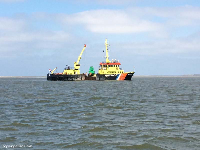 More to follow. |
|
|
|
Post by tedp on Aug 7, 2018 6:34:37 GMT
At Lauwersoog I had to replace the Windex vane in my mast, because the old one somehow had worked loose during the violent movement at sea on our way from Ameland. You can lock into the fresh water basin behind the sea wall and use the facilities of the big marina there. I rented the crane for half an hour and had myself hoisted 15m into the air. They use a safe seat that is much better than a boatswain’s chair on one of your own halliards: 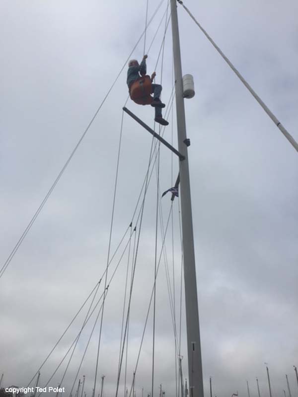 I also loaded up with diesel and water, a good idea before any coastal trip. Soon afterwards we went to sea on the ebb, timing it well to catch the tide east towards Borkum. The isle of Borkum is approached across the main fairway in the Ems estuary from Delfzijl and Emden. Here a fierce tide prevails, often reaching three knots. Borkum entrance is next to a conspicuous beacon on a dam that submerges halfway through the flood tide. There is a roaring tide rip in front of it, but if you approach on a slant all will be well. The entrance is a narrow fairway shared with busy ferry traffic. A mile further on are two harbours. The first is the grandly named ‘Port Henry’, which is a dilapidated mudhole with rickety pontoons that looks like nothing at first sight. It is popular however, and we like the atmosphere. We arrived on a falling tide, but there was enough water left to approach the far side of the floating jetty. Nearest the entrance are very shallow berths, so you need to feel your way in, but further inside are the deepest berths. On the ebb everyone sinks happily into the mud and the harbour stinks to high heaven:    There is a good restaurant overlooking the harbour, and if you want to go into town (6kms away) there is a bus service, or you can rent a bike or walk to the pier station of the island railway 20 minutes away. If you need to leave at low tide, use the other harbour, which has a few berths for visiting yachts but otherwise is occupied by pilot and coast guard vessels. This harbour is uncomfortable though in southerly winds when the swell rolls over the mud flats outside:  On we went to Norderney. There is a sheltered route over the mud flats that can be negotiated even with a 1.50 or 1.80m draught if you time it well. You need to leave on a rising tide shortly after you unstick from the mud, then proceed about 8 miles up the estuary to cross over the shallows into the Osterems, a tributary estuary northeast of the Ems. Then you turn north, following the fairway into the direction of the isle of Memmert. From there is a route east, part of which is a narrow fairway marked with withies called the Memmertfahrwasser. As the timing is vital (parts of the route dry out), do this entire route under engine. You pass the Osterems on a rising tide and the Memmertfahrwasser just after high water at Norderney, i.e. on a falling tide. There is plenty of water under you however - I never had less than about 60cms below the keel on this route with my 1.50m draught. If you have a lift keel, the isle of Juist is tempting, but I never attempted it. Norderney is approached through the swell of the island entrance between Juist and Norderney. At high water you can cut corners, but the safest route is the one taken by the ferries. The harbour there is deep and, in the season, very crowded with boats on their way east. You can hook up to the floating pontoons on the opposite side though. One can walk into town and there is a supermarket close to the harbour. From Norderney we went to sea, on our way to Helgoland.  |
|
|
|
Post by tedp on Aug 7, 2018 21:13:36 GMT
Starting from Norderney, we had to motor out to sea against a two-knot flood tide, as shown in the last photo of the previous post. Then the tide went with us, setting us east as always. Effectively you have to sail to the Harle buoy at the island entrance to Wangerooge first, then turn north to cross the Weser anchorage, in order to keep clear of the traffic separation scheme at sea. The German Coast Guard keeps a close watch on that and not without reason. Passing through the anchorage is allowed, although I would advise anyone to keep clear if any shipping movements are taking place. Having had a quiet sail with the northerly wind and the tide combining to lay us gently over, we now had to drop the sails and motor north into the gentle swell to reach Helgoland. We might have tacked all the way, but it might have delayed us till after midnight, so we used the engine. I left a reefed main up to improve our visibility to ships crossing our course, but it was extremely quiet. After an hour the outline of Helgoland began showing itself on the horizon. 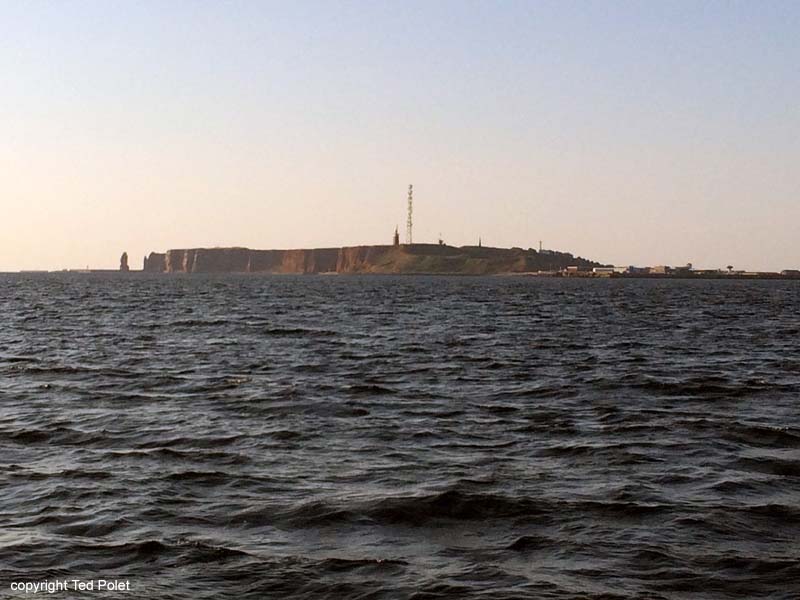 By that time the tide was setting us to the west, so we had to correct our course to approach the island. Note that apart from a narrow corridor indicated in the chart, the waters around Helgoland are forbidden to all craft except those who have a permit. Approaching the harbour is fairly easy if you follow the line of buoys guiding you in.  Finding a berth at Helgoland is not easy. After some time fruitlessly searching a row of boats to hook on to, we settled for a ‘raft’ of four small boats that we were slightly too large to tack on to. All went well however, and after exchaging place with another boat on the outside we took a line to the pontoon (as we were the fourth boat in the row) and made dinner, around 9pm... That night some exchanging took place with boats leaving and we found ourselves no. 2 in the row, with only one boat inside us.  In the morning I went to search the harbourmaster and pay my dues, following which we took ourselves off for a walk over the island, which after about 11am was swamped with day trippers from the mainland. These are carted in on numerous ferries that anchor in the roadstead between the island and its neighbour Düne.  The tourists are ferried ashore using big open boats. We tagged along with the mass of people walking the path over the cliffs. There are interesting views of the coast and of the gannet colony on the cliffs, which is approached by the path to within a few metres, enabling us to see the family life of the gannets from nearby. The birds are used to people walking by on the other side of the fence and continue their life in the crowded colony as if no one was there.  It was a very quiet and hot day, and the sea was calm, so we could see the sandstone bottom just off the cliffs shining through the surface: 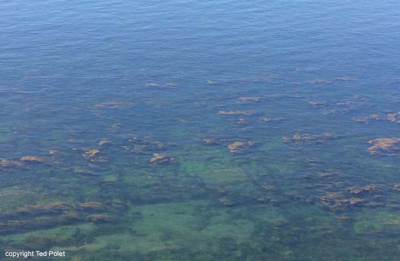 Here is a view back along the path, showing the lighthouse and radio tower:  The other side of the island is inhabited and has private vegetable gardens and even a football field:  Back on board I shot this photo of the largest lifeboat I have ever seen approaching its berth close to us: 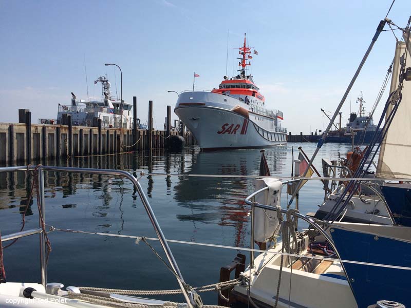 Having done our shopping and stored up on tax free products, the next morning we cast off to make for Wangerooge. |
|
|
|
Post by tedp on Aug 8, 2018 8:29:38 GMT
When we returned from Helgoland there was a westerly 4 blowing, which quickly helped us on our way south to the isle of Wangerooge. I had timed my arrival about halfway the flood at Wangerooge. The Harle entrance is shallow and there was a slight swell running, which always quickly springs up in westerly or northerly winds in the German Bight. We made good progress and gradually the outline of Helgoland disappeared behind us. Once again we threaded our way through the crowded Weser anchorage, then crossed the Wilhelmshafen fairway and approached the Harle buoy which marks the start of the entry channel. There was the usual bumpy ride through the shallow entrance, then soon we saw the harbour open up to our port side. The harbour dries out partially, but the yacht basin is well dredged and protected by a dam. The photo shows the barrier on the left, sheltering the yacht basin:  Here is the basin itself, with our boat tied up along a floating pontoon:  Wangerooge is a pleasant little island where cars are banned. All transport takes place using the railway, which carries ferry passengers, luggage and freight two miles into town and at high tides frequently runs through the water. For local transport a few electric trucks are employed.  The island affords walking and cycling and has a good beach. In the town are various restaurants. But note that the railway only runs in connection with the ferries and ceases operation at low tides. You may have to walk back to your boat if you miss the last train. We rented bikes and went to the eastern end of the island. Walking on the beach we found the remains of piles where the railway had once run to a now abandoned ferry pier - the sand had reclaimed the former fairway.   The next morning we were on our way back to Norderney, using a favourable southerly wind. |
|
|
|
Post by tedp on Aug 8, 2018 9:16:56 GMT
In Norderney the weather already showed signs of heating up further. Up to now this has been an extremely hot and dry summer in northern Europe. As I write this a week after returning home, finally the weather seems to be on the turn. We had planned to meet our son and daughter-in-law at Borkum, and spent another day at Norderney before leaving early the next morning.  Now we had to do the reverse route to Borkum, negotiating two creeks that dry out at low water. The same principle applies: sail a few hours before high water, cross the first watershed on a rising tide and make sure you are at the next one before the tide drops too much. Use your engine and don’t waste time trying to sail unless the wind is favourable. Sailing early in the morning has something magical. Apart from an occasional fisherman, almost no one is about. I always sail after nothing but a cup of tea, and once we’re underway we make breakfast and coffee, provided it isn’t too rough. This time there was hardly any wind, as would be the case during several days. Around noon we arrived at Borkum and that afternoon we collected our crew from the ferry, which is 20 minutes’ walk from the yacht basin.  Due to the lack of wind, the next day we decided to cross back into the Osterems estuary and anchor, spending the day swimming and using the dinghy to walk on a dried out sandbank. On our way there we passed a barge heading out to sea to install wind rotors.  I also had a closer look at the islet of Memmert, which plays a prominent part in Erskine Childers’ spy novel The Riddle of the Sands, written over a century ago. Predictably there was nothing there!  From the Osterems anchorage we used the flood tide to go to the fishing port of Greetsiel on the German mainland. This now lies in a fresh water basin behind a sea wall and a lock. The approach channel to the lock is very shallow and cannot be used two hours either side of low water. It is buoyed, but the last green buoy is out of position and we grounded next to a tide gauge post. We were on a rising tide however, and a few minutes work with engine and rudder backed us out safely, feeling our way to deeper water. As we entered the final stretch of the channel, we noticed a green light on the locks, beckoning us in. An hour later we tied up at the Greetsiel yacht club. Well... tied up is a bit misleading as we were hauled through the mud till we almost touched the pontoon. Even at 1.50m draught we hardly managed to reach it. Greetsiel is a picturesque sight with the fishing boats in. Here is a 2015 photo:  The town itself is full of tourist shops and restaurants, and fresh fish can be bought on the quay. There is a supermarket not far from the harbour. There are several historic buildings such as the church with its panelled 18th Century interior:   The word ‘Siel’ in this part of the world means a drainage sluice. Formerly at low water the excess water from the low-lying land behind the sea wall was drained off here. This preserved sluice is over 200 years old:  After having eaten at a waterfront restaurant we returned to the boat, seeing this:  The next morning we unstuck from the muddy berth and made our way back to sea. |
|
|
|
Post by tedp on Aug 8, 2018 9:58:31 GMT
And then we were back in Borkum, where I had to say goodbye to my entire crew, all of whom had to return home to work, whilst I (the lucky one) stayed on board to sail the boat home on my own. 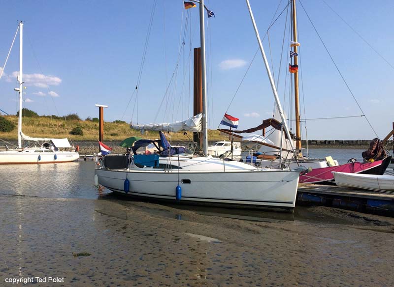 I took them all to the ferry terminal, and after having seen them off, I walked back to the boat, past the deep water harbour where the light vessel Borkumriff is laid up as a museum. I remember when it winked at me, forty years ago when I sailed as a merchant sailor, as I passed by on my way to Bremen or Hamburg. 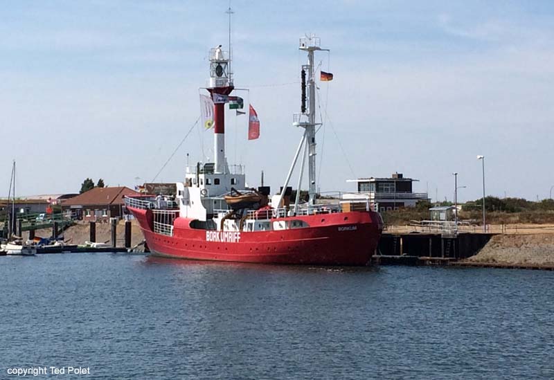 The next day I caught the westgoing tide, bound for Lauwersoog again, initially in another flat calm, but soon enough a northerly wind sprang up which enabled me to set sail. Later I heard it had been an extremely hot day ashore, but I hardly noticed it. 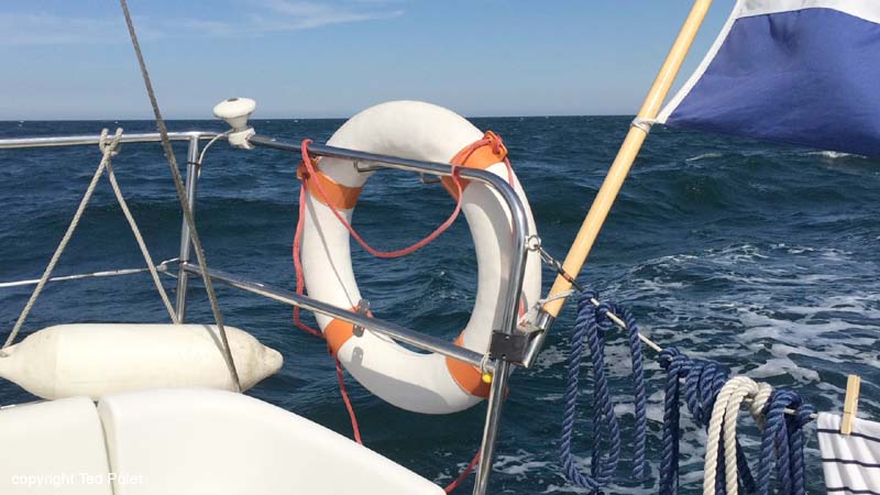  At Lauwersoog I took a days' rest, then, with a southerly wind, I departed, intending to reach Vlieland again. The elements decided otherwise though. I had been on my way for about 5 hours on what was intended to be a long passage, when the southerly wind suddenly whipped southwest and increased to a force 6, forcing me off course as seen in the tiny angle in the course pictured in the chart below. I reefed down (second reef and the genoa rolled in about halfway) and went into it for about an hour. It became increasingly rough in wind against tide conditions, so I considered stopping at Ameland. I tacked in preparation, to get myself closer inshore before searching out the approach channel a few miles more westerly. However, conditions became too rough to even consider that and I had trouble managing the boat (more of that below). So I turned back: 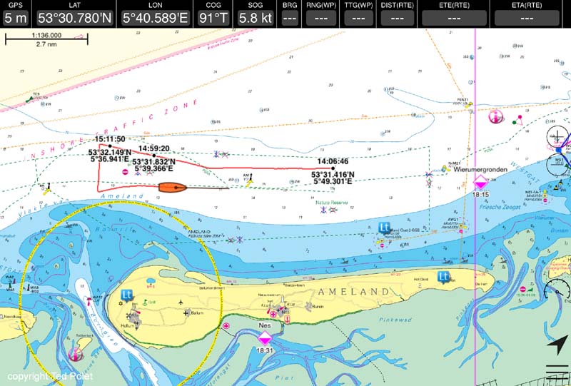 I hauled my wind and returned to Lauwersoog, putting the boat before the wind and sailing against the tide for hours. Eventually, the elements had a final laugh at me as by the time I was back in, the wind had dropped to almost nothing. The cause of all the trouble had been a tiny atmospheric disturbance: 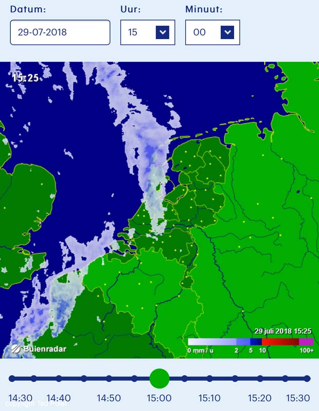 In hindsight I might have tried continuing, but being on my own it needed only a slight mishap to be in serious trouble. The boat was difficult to manage, even though I have often sailed in similar conditions. I think it must have been the ebb tide over the bank seen in the chart image, combined with the 25-knot wind and the fact that I had the wrong genoa hoisted: the original Technique Voile sail which doesn't roll in nicely like the other genoa I have. The boat only wanted to heel, and the rolled-in sail looked like a bag. In those circumstances the best choice from a seamanship point of view was to turn back. I turned back on a few other occasions and never regretted it. |
|
|
|
Post by tedp on Aug 8, 2018 10:31:37 GMT
So now we have arrived at the final post describing my 2018 summer cruise. The next morning I made ready for sea again. This time in another flat calm that was to persist the entire day and evening. Luckily I had filled the diesel tank the previous day, so I went out again on the ebb, with the engine at slightly over 2000 rpm and the boat drowsily ticking away the miles. All day I sat in the cockpit, with a book to pass the time, periodically looking at the empty horizon. It was like sitting on the Dunkirk-Dover ferry!  All I needed to do is watch the course and correct for the tide setting us in or out. At Ameland entrance, where I had to turn back the previous day, it was noticeably bumpy despite the quiet weather, but soon afterwards the swell died down and I continued lazily past the Terschelling coast. I made dinner at sea, heating up a tin of soup and eating buns and cheese with it, and slowly the sun started to sink. In order to make the Vlieland entrance you have to pass about halfway along the entire island of Vlieland before turning inshore, due to the formidable collection of sandbanks between Terschelling and Vlieland. Note me hugging the 10 metre line in the chart - a big motor yacht on the same course behind me had turned inshore earlier, but was forced out due to the very shallow water he encountered: 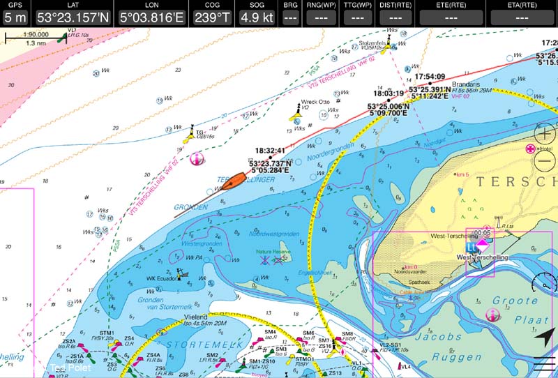 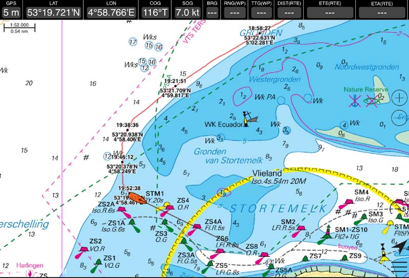 Since the island harbours were all closed due to congestion, I decided to carry on to the mainland port of Harlingen, running with the flood under me. I considered jumping the shallows and going to the locks in the sea wall at Kornwerderzand directly, but that fairway is unlit and I'd be negotiating the shallows after dark. Not a good idea, and luckily I didn't because I was caught in a blow at 23:00 just before I arrived. Before that I experienced a lovely sunset - the first photo shows the isle of Vlieland in the distance:  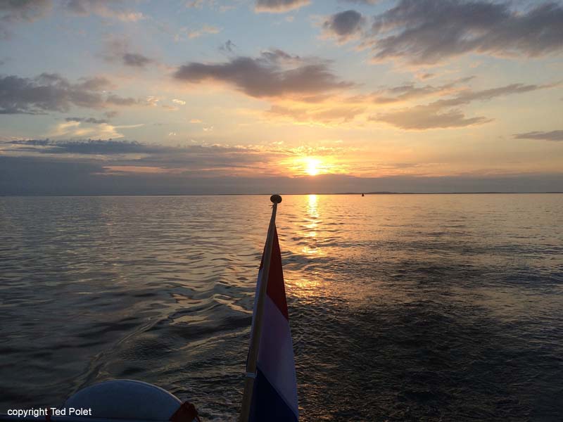 So I switched on the navigation lights and carried on to Harlingen, with the buoys lighting up one by one and the lights of the town in the distance. Some of it can be seen in the video I published of the trip. A mile out suddenly it began to blow again and within a minute I had another 25 knot gust on the clock, so I entered Harlingen in a blow. By then it had gone pitch dark and I was drifting round like a zombie in the outer basin until I noticed the traffic control signals on the swing bridge going red and green, indicating they were going to open the bridge for me. Soon afterwards I tied up to a barge moored in the intermediate basin and turned in, having been on my legs for 12 hours. The next morning I made a few photos in harbour and visited the supermarket before we had the mother of all downpours. Right across the narrow basin was a 1950s lifeboat, now preserved: 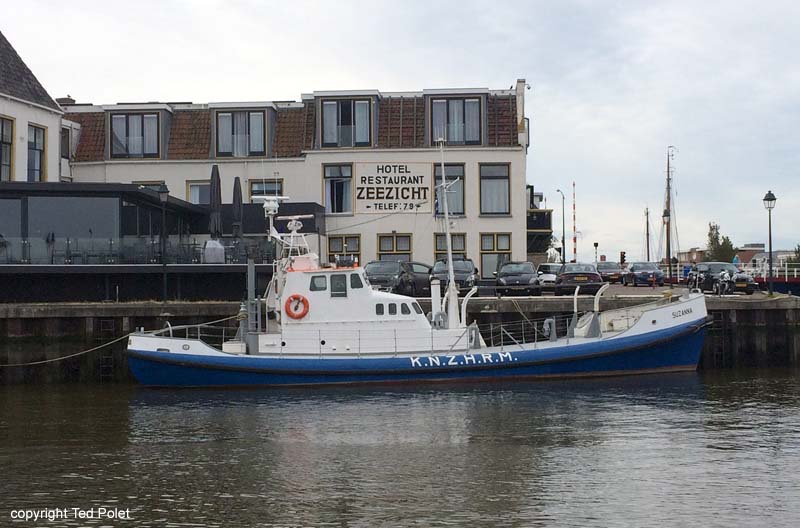  After the rain had stopped and just before they were about to close the flood gates under the bridge, I left Harlingen for the locks at Kornwerderzand 7 miles away. It was extremely crowded there, but eventually I found myself in home waters with a favourable westerly wind. Once again the wind increased to a force 6, but in the absence of swell and tide the boat was easier to manage, even though I still had that same dodgy foresail on the stay. I reefed down and carried on, flat on my ear...  The cockpit floor was a mare's nest of cordage - halliards, sheets and reefing lines cluttering the entrance to the companionway.  Three hours on, I took in sail and tied up in my own berth. I connected up the power lead, opened the hatches for ventilation and sat down with a well-earned beer! |
|
